Spatial Conjunctions
Caroline Humphrey
Introduction
This paper is about contrasting spatial ideas and the co-existence in one country of radically different ideas about landscape. It will be concerned with contemporary Russia, which includes within its sovereign space various peoples, such as the Buryats, that perceive their environment in ways that are quite alien to Russians. Such cases have usually been analysed by taking each ethnic culture separately, but it is important to try to go beyond such singular accounts because they fail to theorise the fact that one massively dominant discourse geographically and politically encompasses the other. But the problem is not only one of how to analyse the enclosure of difference. For the Buryats are historically people of Mongolian culture, and many of them live over the international border in Mongolia where their kind of landscape thinking exists in an alternative, and these days definitely non-Russian, political realisation. What the paper tries to get to grips with is a situation that must be analogous to that found in the borderlands occupied by ‘minorities’ in many imperial, colonial and large national states. In such a situation, there are two anthropological questions that arise – one is political in a broad sense, how to analyse the conjunction (or, overlap, friction, confrontation, relegation, etc.) between incompatible visions, when one is incomparably more powerful and contains the other within it? The second question could be pictured as ‘horizontal’, since it concerns the morphological transformation of a certain type of landscape thinking in two or more sites, when it is part of adjacent, but different political systems.
‘Landscape’ is not an obvious idea and I need to say what I mean by it, because my use of the term affects the kinds of information that will be presented in this paper.[1] Anthropology has tended to use the term quite loosely, leaving behind the conventional idea of pictorial representation of a scene to embrace any purely conceptual imaginary of space. Meanwhile ‘-scape’ has become a suffix added to a whole range of denominators: such as ‘soundscape’, ‘touchscape’, ‘smellscape’ or ‘taskscape’, all of which attempt to overturn the Eurocentric emphasis on the visual in the evocation of spaces and places. Studies that focus on these phenomena are certainly valuable, but they leave the term ‘landscape’ itself unclear. Luckily, our French colleagues, the geographer Augustin Berque and the anthropologist Philippe Descola, have been working intensively on this question and have clarified a helpful usage of the term. In their view, a landscape exists as the interaction between two realities that are distinct, but difficult to dissociate from one another: a geo-physical biological reality that pre-exists any vision of it and which therefore can be described in any language, and a ‘phenomenal’ reality that is captured in a human field of vision and charged with a particular signification and affect. A landscape is neither outside the observer who contemplates it, but nor is it purely inside that subject as the expression of an internal experience. It is the result of a structure of interaction between an individual or collective subject and a physical site. Therefore, for ‘landscape’ to exist there need to be perceptual models that function to integrate the salient properties of the physical object with the schemes of cultural representations of that object. Both Berque and Descola argue that the visual is always important in such perceptual structures, yet only the modern West has prioritised vision by relegating the other senses, while other societies tend to mobilise an ensemble of other sensory faculties at the same time. Whatever their sensory nature, such models can be very resilient, becoming ‘prototypes’ or ‘clichés’, and they can diffuse as visual, oral or literary tropes well beyond any faithful representation of an actual place (for example in paintings of imaginary landscapes, the creation of gardens, or bucolic poetry). In some cases, such as Chinese painting, such schemes enable the depiction in a two-dimensional image of correspondences between the human person and the cosmos. Such paintings – by allusion, or by leaving blank spaces – suggest to the imagination what it is out there in the world that has ‘intentionality’ (yi) corresponding with human dispositions (Berque 1994: 18-21). So to summarise a far more complex set of arguments, for there to be ‘landscape’ it is necessary for the perceiving subject to have available for thinking, feeling and taking action a combination of prototypical traits that can be linked (or not) to the physical-spatial sites encountered (Descola 2013: 656).
This is where Descola poses classical anthropological questions: does one have to have one’s internal museum stocked with stereotypes of landscapes in order to be able to contemplate a space as it were in the form of a ‘picture’? Should we agree that the absence of such pictorial images does not imply the absence of the internal state that the concept of landscape implies? And does not the idea of landscape simply reinstate the idea, long-abandoned in anthropology, of a nature-culture divide? These questions may seem rather arcane today, but they are pertinent to my case: the Russians do without question possess a rich tradition of visual representations of landscape types and clichés, and the effect of this tradition has in fact been to reify a distinction between civilisation and wilderness (which one might align with ‘culture’ and ‘nature’), but the Buryats do not have a similar repertoire, and for them to distinguish ‘nature’ from ‘humanity’ would not make sense.[2] The Russians’ objectification, ‘naturalisation’ and consequently their practical transformation of ‘nature’ (priroda) contrasts with the Buryat–Mongolian conviction that their physical environment should as far as possible be left untouched – although this does not mean that they do not ‘shape’ it conceptually. Descola summarises the baseline from which one might begin to analyse any specific case as follows: ‘There is an irreducible difference between any environment and its deliberate transformation, whether this is realised in situ by means of the practical reorganisation of space, or whether it is realised in visu, in the form of a perceptual schema serving as a model for figurations’ (Descola 2013: 658).
The Russians, as I shall now attempt to show, have transformed their own environment in both of these ways. But in doing to they have also created what one might call the ‘multiplied environment’ in which the Buryat citizens of Russia perforce live – in other words, not only transformed geographical surroundings but also the perceptual schemas that are inseparable from them that Buryats imbibe from the Russian language, from school history lessons, visits to museums and art galleries, and so forth. From all this they also learn something that an anthropologist must also account for: landscapes certainly involve the perceptual schemas mentioned by Descola but they drag in too – or more correctly they manifest – whole cosmologies made up of political/military preoccupations, aesthetics, and religious convictions.
The spatial order of the Russian state
The Russian transformation of the Siberian environment (forests, rivers, steppes, etc.) historically went hand in hand with certain visual schema, as can be seen from early maps. But to make my exposition of the present situation clearer I first outline the organisational structure and then present the ideological-pictorial landscape within which the Buryats dwell. It will be argued that the Russian state in its Tsarist, Soviet and post-Soviet variants being an extreme example of centricity – concentrating all lines of governance, infrastructure, and communications towards the metropolis – has at the same time generated a geographical pattern of inattention and deprivation across many provincial regions.
By the 2000s, aghast at urban sprawls on the one hand and the desolation of former agricultural lands on the other, the radical geographer Boris Rodoman[3] argued (2004) that Russia was seeing the consequences of the hyper-development of an ‘anisotropic’ society, one in which vertical links are very strong while horizontal ones are weak. Successive generations from Catherine the Great onwards had produced an administrative-territorial division of Russia whereby lands were incrementally added to the core, and although this core shifted location in different historical periods the same structure was reproduced in each case. The metropolis was linked by radial lines to the centres of regions, the capital of a region to the provinces within it, the provinces to the districts, and these to local communities. The transport system was the reflection of the administrative divisions, and vice versa, and thus radial roads that connected the centre with the periphery were a manifestation of the power vertical. Rodoman argues that it is wrong to think first of points (towns) and later of the roads that connect them: historically it was the presence of routes – initially rivers and later roads – that determined the sites of towns.[4] Being based on existing infrastructure the pattern was difficult to change, and the same roads, provinces, and their boundaries tended to persist over centuries despite dramatic political changes and superficial reforms.[5] In fact, Rodoman calls the whole system sclerotic (2004:1). So when new communications were added by the Soviets, such as telegraph and telephone lines, they again followed the old routes, connecting the Politburo with the Party Secretary of the regional centres, the provincial party leader with the district subordinates, and the raion (district) bosses with the directors of enterprises. Modernising policies to expand production and tame nature resulted in the addition of outlying industries and farms, new roads, railways, electricity lines, bridges, air connections, postal services, etc. But today, after the retreat of the state in the 1990s, many of these Soviet links have atrophied or been abandoned altogether. Now the only roads kept in good repair are the radial ones used by important authorities (nachal’stvo). To go between two small towns, one frequently has to travel first to a centre and then out again. Side roads between remote villages exist only as meagre tracks, easily obliterated. The absence of lateral connections is the weakness of the anisotropic society and makes Russia unlike any western European country.
Rodoman argues that because this order applies not only to roads, but also to public services, telecommunications, allocation of funds, and distribution of gas and other supplies, it creates enormous inequalities, which people feel very strongly at each level. If we apply his idea to Buryatia, there is a huge difference in prosperity between life in the capital Ulan-Ude and some outlying district centre of the same Republic, and a similarly great one between the district centre and the poverty-stricken villages in its peripheries. This acute inequality, combined with the ability to compare one’s own with other places, is central to post-Soviet experience.
Rodoman continues that the structure results in a significant geographical pattern – the decaying zones (upadochnaya zona) tend to occur on the edges of each administrative unit. This is where the bus routes end, where it is ‘not worth’ having schools or medical services. Borders are politically crucial in order to designate the edge of each jurisdiction (particularly that of the Russian Federation as a whole), but the lands along them are consequently turned into ‘peripheries’ and a kind of vacuum. ‘Where three boundaries meet in one place, real godforsaken pockets (‘bear corners’ medvezhyi ugly) result’ (2004: 4). Furthermore, along international borders Russia has instituted ‘exclusion zones’, wide bands of territory where no activity may take place without the permission of the Federal Security Bureau (FSB). Thus border zones are where investment contracts, where depopulation is strongest, where there are fewest villages and those that exist are decaying (2004: 5). Since Rodoman’s scheme applies on all scales, even including the peripheries of Moscow Oblast, we can see that when the state structure of communications atrophies, the condition of remoteness creeps ever closer to great cities (Humphrey 2014).[6]
How does this relate to structures of perception? One could argue that the centric management of space provides a template of – or alternatively derives from – a characteristic spatial orientation of the subject. Here I recall the insights of Edward Casey when he writes of the purpose of orientation – to turn an apparently vacant expanse into a set of what can only properly be called places, by which means one knows bodily where one is (Casey 1993: 28).[7] Rodoman writes that he felt disoriented when travelling in the Baltic countries, because they, unlike in Russia proper, do have dense infrastructure networks that go in all directions. But in Russia, he writes, ‘I can always sense where the centre is and where is the periphery, in any village, in any forest I can feel it, where is our centre and our edge (okraina), which is the direction of Moscow’ (2004: 3).
Richard Stites, the historian of Russia, describes a seamless conjunction of the desire to be closed in and the love of openness in his paper ‘Crowded on the edge of vastness’ (1999). He shows how this duality is manifest at diverse scales, from the doorways of official buildings to the plan of shops, ticket offices and libraries, and including the layout of cities. ‘Inside’ is designed to be crowded, warm, communal, while the ‘outside’ is, and should be, ‘unbounded’ or ‘undefined’ (neob”yatnyi) and therefore to be used according to one’s will or freedom (volya). Rodoman (2002b) deplores this attitude, pouring scorn on what he sees as only the latest re-conquest of the wild, the destructive and polluting scourge of the ‘dacha boom’. Indeed, these days between 65-80 million townsfolk make daily or weekly journeys out of cramped, cosy apartments to their dachas (country cottages and vegetable plots), sometimes travelling hundreds of kilometres and taking over the houses abandoned by villagers (Nefedova 2001). The great majority of the inhabitants of cities, from the poorest to the richest, lead a ‘distributed’ way of life, migrating between their main and secondary dwellings (Kordonskii 2002). Yet this mass movement outwards from each city is not indiscriminate, because dacha construction follows the electricity lines, railways and main roads. In other words, even the attempt to escape the city is a re-affirmation of the centric–radial scheme. At the same time, it is so widespread that it implies the existence of a common idiom of orientation as part of everyday practice among urban Russians.[8]
Russians landscapes
I would now like to move from the transformation of environment to Russian landscape, in the sense discussed earlier.[9] Of course Russia has many discordant voices and diverse points of view;[10] here I am only able to highlight some tropes that are culturally pre-eminent among broad swathes of educated people. First, we can note how language codes verticality in conceptualizing the largely abandoned outback. The term upadochnaya zona, used by officials, geographers and the media to describe ‘failing zones’, means literally falling, referring to a vertical drop. In other words, the desolate zones at the edge are also the ones below. Russian vocabulary referring to remote places includes the idea of distance (udalennost’), but also in everyday speech refers to depth. Thus townsfolk refer to rural hinterlands as glubinka (from glubina, depth, deep places, also heart or interior), and when in an abandoned, overgrown state such places are known as glush’ (roughly translatable as ‘isolated depths’). The implicit orientation of the speaking subject is facing out and downwards to an object below. This stance also implies a structure of worth, usually the uncouthness or insignificance of those ‘down there’, which corresponds to the inequality mentioned earlier – although it is also true the signs can be changed in some contexts so that depth can imply something profound, ancient and worthy of reverence (Humphrey 2014).
Another clue about landscape concepts comes from a paper by Rodoman (2010), entitled ‘The inspiring view across the river’. This is a historically robust culturally transmitted image, the view taken from a high bank, across a wide river, gazing over vast expanses of wilderness to the horizon. Many Russian towns were in fact founded on such riverbank sites as the advance posts of the expansion of the empire eastwards across Siberia. Such a high position has a military advantage, but as landscape it also becomes a subjective experience, like standing on a balcony viewing the scene.
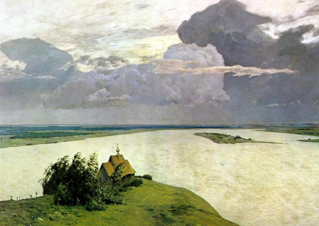
Levitan ‘Above the Eternal Tranquility’ (1894)
Behind your back are the familiar streets, the bustle of life, while across the river there is – or should be – nothing. Such a landscape is inspiring when it is vast, uninhabited, silent, secretive, and empty. Looking outwards, one feels oneself standing ‘above eternal peace’, or in poetic variant ‘above the gentle rustling and swarming of “our small friends” – glimpsed birds and small animals’ (Rodoman 2010: 61). The river here is not a route but a boundary, which preserves the difference in principle of the other side. From the balcony, Rodoman writes, the viewer greets the forests and waters like a tsar, yet paradoxically both looms powerfully over the extending vastness and also bows before its greatness – a greatness greatly exaggerated by desire for it to be so. To feel the full effect, the viewer should know that Moscow is behind him, while what is in front is imagined to be a grandiose, luminous wildness and foreignness.[11] The Levitan painting simply would not work as ‘pointing towards Moscow’. The same is true of countless pre-Revolutionary and Soviet paintings that present a road stretching from the viewer into infinity.
What about the people living out there in the mid-distance – people like the Buryats? The inspirational landscape requires openness and this, I suggest, renders native denizens of remoteness, who are obstinately different people and not murmuring animals and birds, inadmissible to the vision. It is not, of course, that there are no documents, paintings and maps depicting imperial conquest and the subjection of peoples, but these have been historicised to the Tsarist period (or to Soviet versions) and have not survived to the present day as popular visions, unlike the inspirational (vdokhnovlyayushchiy) landscape. The latter, which might better be translated as ‘landscape of exaltation’, requires that raw power be bracketed off. Thus although the mediating schemes for traditional Russian landscape painting work in principle through mimesis, i.e. giving the impression of copying an actual landscape, in fact this naturalism is inflected by a substitution of religious/national/spiritual for political preoccupations. The church with its cross in Levitan’s painting is a suggestion that the uninhabited space it addresses is not Christian.
Here it is worth adding that Rodoman’s ‘inspiring view’ also implies a soundscape of ‘the unknown’.[12] Each river that must be crossed can be the border with an enemy country. Over there, to quote, ‘the enemies are quiet, they try not to make a noise, speak in whispers, and they look vicious. This is the almost folkloric image of the Soviet frontier, which we have involuntarily inherited from our ancestors. The key understanding of the border is silence – deceptive, worrying, and malevolent’ (Rodoman 2010: 64). In post-Soviet times, Russian nationalists have built churches on the border with China, some of them far from any town, yet whose bells ring out.
Even far from international frontiers many of the ‘ordinary’ great forests and swamps that constitute Russia’s interstitial spaces have been used in a highly secretive, and also silencing, way: as sites for prison camps and as areas cleared of population for military exercises (poligon).[13] As for the national parks and nature reserves across the country, they almost all overlap with military installations, serving it seems to disguise them (Rodoman 2010: 64). The lands inhabited by Buryats are no exception to all of this.[14] So the Buryat ‘environment’ that I shall now discuss does not consist simply of steppes, mountains, rivers, etc. but of these in a state already physically transformed in selective ways and already interpreted in powerful cultural tropes.
An alternative geography
Perhaps the most evident minoritarian[15] feature of Buryat geography is not that it dispenses with the notion of ‘centre’ but that it makes this idea the pivot of cosmological fortune in place of political power. The previously shared Soviet ideals attached to the political centre – equality and the dignity of labour – having long since evaporated and been replaced by what is seen as a newly alien raw power, Buryats have turned to their own, quite different concepts and scalar visions of what a centre might be. Buryat geographical ideas were influenced by Mongolian, Tibetan, Indian, and in some places Evenki, epistemological cultures and cannot be understood in general to be constituted only by a dichotomous relation with the Russian; but the ways these Asian ideas are actualised by Buryats in situ today are inflected and re-cast, I suggest, by non-recognition of the Russian structure, ‘absenting’ it, while replacing it with an alternative: a figure-ground switch, one could say. Absence has become a topic of interest in post-Soviet studies (Dunn and Frederiksen 2014), and I would like to specify here that I am not referring to a previous presence (e.g. an object of nostalgia), nor to a promised thing (absent because it has yet to appear), nor yet to a gap in a network of meaning (absence in the sense of the inexplicable), but to a switch to another ‘optic’ in which practical political power either is not talked about at all or is made to appear in an alternative form, as a repentant sinner or tributary to spiritual power.
As pastoralists, Buryats prefer to live in the open, treeless grasslands of wide valleys. Their villages are not usually located beside the rivers (gol), which may flood, but some distance away, often nestled in a sheltered area at the foot of hills. A large valley system forming a ‘homeland’ (nyutag), such as that of the Dzhida, Barguzin or Chikoi Rivers, includes a number of branch valleys that are separated from one another by forests and low-rising hills. High mountains (uula) separate one valley system from another and these peaks are worshipped both in themselves and as points in contact with the sky, the realm that regulates the whole world. The ideal local landscape thus has the form of a broad bowl, with the powerful foci not in the middle but at the high periphery.
The mountainsides are dotted with shrines,[16] of which the most important are oboos, stone cairns often constructed on the tops of the mountains. It is at these peaks that communities gather annually to sacrifice to the land master spirits (gazaryn ezhed, sabdag), which frequently are not distinguished linguistically or in practice from the mountains themselves. The mountains are imagined as active, ‘giving rise to’ springs and rivers, and nurturing grasses and animals, and thus creating the fertility and prosperity of living beings. Humans participate in cycles of physical and spiritual existence as the deceased are interred on mountainsides and the placentas of the new-born are also buried in the earth. Most mountain spirits are held to be the transformed ‘souls’ of ancestors of local groups that have merged into the land.[17] People hold that their social groups cannot survive and reproduce themselves without their blessing, and conversely that severe disasters, illness and early death happen because the mountains/ancestors have been wrongly treated. Indeed, stories about remarkable ancestors and shamans are the main discursive basis of the groups’ existence, and these mountain rituals are the major occasions when the members come together. When I travelled in summer 2013 among the villages of the Buddhist Tsongol Buryats in the Chikoi area, I was told that each patrilineage (ug, yahan) in the neighbourhood had its own mountain with an oboo, and that on the same day in summer the male members of each group would climb up to their own site to make offerings and ‘meet’ their ancestral spirits. Later in the month, following these separate rites, the men of all the related lineages would join together and go to the highest mountain of the vicinity for a common sacrifice.[18]
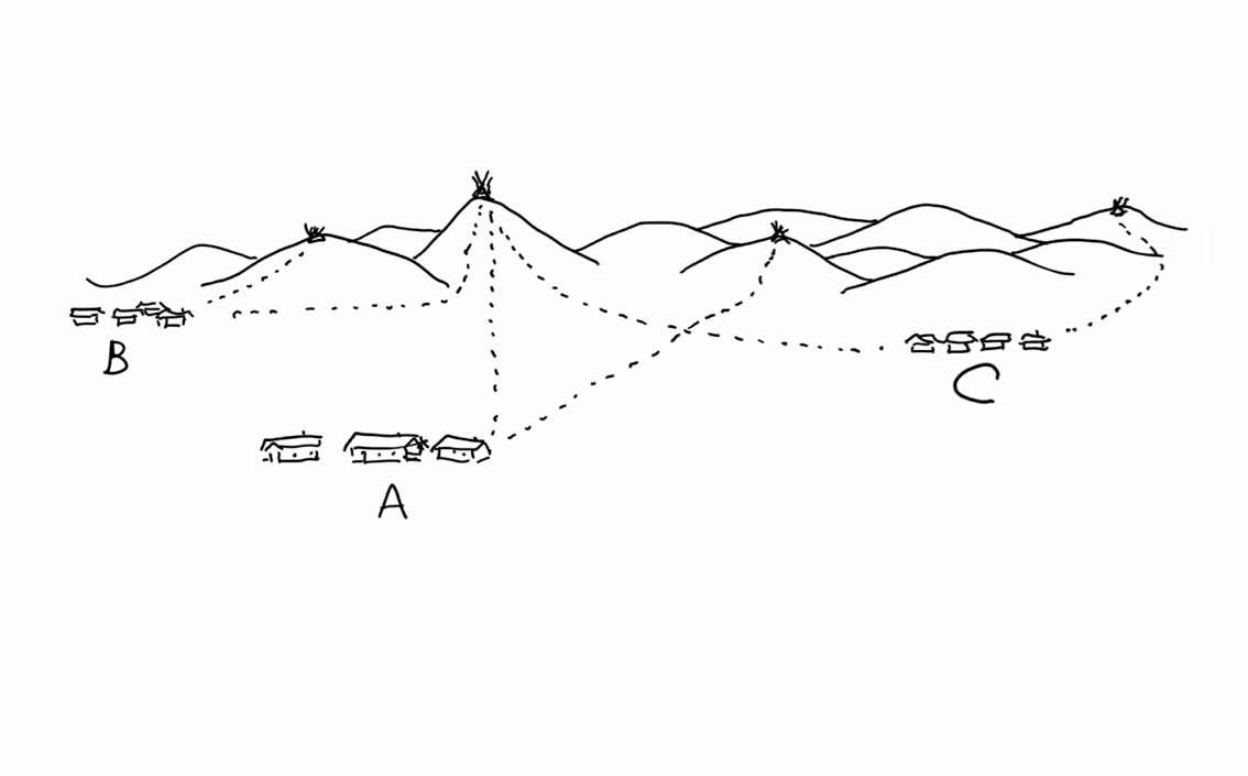
Sketch of village-clan worship, by the author
These dominant mountains are called Khan (‘king’). Being so high, they are difficult to access; no roads reach the summit, and people have to walk or ride on horseback. The Khans are located on the edges of a set of communities.
It can be seen already that this Buryat set of ideas and practices contrasts strikingly with the Russian state system. First, this is ‘cosmopolitical’ geography in the sense proposed by Stengers (2005; see also Sneath 2014). It explicitly acknowledges and treats as ‘intentional’ the force of non-human geophysical elements, rather than seeing them as inert objects. Second, as a spatial concept, instead of the Russian conical structure, which has ‘height’ and political power at the centre and ‘depth’ in the gaps and edges, the Buryat bowl-shaped version locates highness and spiritual lordship at the boundaries. The topographically central area, which is low-lying and not necessarily even inhabited, has no obvious feature to align with political centricity. Even Buddhist monasteries, which might in principle be seen as centres, were traditionally set many kilometres away from villages, their sites being chosen by reference to a protective mountain.[19] As for the administrative nodes of the state, such as the ‘district centre’, they are part of a different system and screened out from this geography.
The political absence at the heart of the Buryat landscape must be related to the colonisation of extensive tracts of their former lands – to the fact that for centuries their political masters have been ‘aliens’ (Russians) while their own potential leadership hierarchies were truncated at local levels.[20] Nevertheless, the Buryat geography is not inherently lesser than the Russian. It is also centric, but in an utterly different way. The peculiar character of this type of centricity is that the oboo is a centre that is a joint between realms. Looking upwards from the village, only one side of the mountain is visible. It appears as an edge, beyond which nothing can be seen. But the rites require that people go to the summit, where a vast new vista opens out, and it is of this entire expanse that the mountain is a centre. The purview of the summit includes both what is behind us and what lies before us. This is why a great mountain will not only form the border between communities but also be the point that links them, since people from the other side come to worship there too.[21] Great oboo rites provide the occasion for a gathering of groups that otherwise would never meet. In southwest Buryatia people of all clans converge on Burin Khan mountain: on the same day, the 2nd of the last lunar month of summer, the villages of Iro, Udunga, Tashir, Selenduma and Nandi arrive from the eastern side and people from Inzagatui, Borgoi, and Ichetui come from the west. At the summit there is a lake. Twelve small oboos are set in a circle surrounding one large oboo and each of the small cairns is worshipped by a different clan (rod) (Abaeva 1992: 79).
The Buryats’ geographical ideas derived from their former way of life as transhumant pastoralists did not emphasize a practical notion of boundary, if only because the edges of each group’s reach was constituted by the furthest pastures of untended mobile herds, some of which (horses and camels) strayed far and wide, especially in steppe zones. Only in the case of the winter settlement did people return to the same place year after year (Sodnompilova 2005: 178; for northwest Mongolia, see also Pederson 2009: 141). The boundaries on which oboos were set were notional, marked by ritual activities.[22] The oboos marked only key points in the landscape, and similarly the people necessary for the accomplishment of the rites were not everyone but only those representing the conceptually important nodes of human groups.[23] This means that today, while some oboo rites are crowded community festivals many are attended only by a few elders. What is important is that at due times, by someone, the mountains that govern the lived world should be given due respect.
The idea of the oboo has its own scalar magnification. Reaching the top and seeing other mountains in the distance, people say, ‘We worship them too.’ In this situation they recognise analogous relations between series of mountains and associations of social groups. The relation between smaller and larger oboos is often modelled in the same way as senior/junior lines of patrilineages,[24] while mountains thought to be on the same scale draw together wider ‘horizontal’ associations, such as the ‘seven clans’ in the Selenga border area originating from western Buryat lands, the ‘eight clans’ originating from the east and Mongolia, or the ‘Nine Grey-Haired Fathers’, said to be brothers, linking a further assemblage of groups.[25] These broader inter-regional agglomerations are said to gather to worship the greatest King (‘Khan’) mountain spirits, such as Burin Khan, who has become an almost deity-like figure, usually pictured as a mounted warrior brandishing weapons.[26]
The links between mountains are as varied and endless as those between kin. Locally, each high peak has lesser mountains nearby that are said to be his ‘wives’ and ‘children’ (Sanzhe-Surun 2013: 189-91; Humphrey, 2014). Mountains are said to have snatched brides, taken other mountains as lovers, fought one another, etc. and such mythic events enable people to talk about mountains in the incipiently hostile tropes of affinal kinship (the sister’s son, for instance, typified as someone who comes to stay long term, eats up the food, and when faced with resistance, yells defiantly ‘Everything in this house is mine!’). Far from European notions of tranquil or energising ‘nature’, the objects in the Buryat landscape can be the agents of everyday misfortune. Therefore people treat the physical environment with great caution – because practically every object in it is regarded as intentional, i.e. having its own course, and taking offence if this is hindered, and therefore dangerous. There are numerous precautionary precepts (the land around oboos should not be used for pasturing, agriculture, hunting or gathering; the names of sacred mountains must not be pronounced; washing should not be done in rivers; branches should not be taken from living trees, and so forth). The general effect of all this is that the environment is left unchanged, as far as possible.
The Buryats in the Russian environment
This ‘leaving unchanged’ turns into a number of minoritarian practices when it concerns the parts of the environment categorised and transformed by the state. I mentioned earlier the verticality of this structure, and one of the Buryat practices is to insist on the uncovering of place names: the names now used in maps and official documents are said to be Russian mispronunciations of the real Buryat names that ‘lie underneath.’ A friend of mine recounted how, each time her father met her from the bus bringing her back from boarding school, throughout the long drive to their remote home he pointed to every road sign and said, ‘That is not its real name. This was our land, and you must remember that its real name is X (a Buryat name).’ After repeated waves of state-directed settlement of Siberia, no districts of Buryatia are inhabited only by Buryats.
On visits to Buryat kin living in other villages travellers ignore Russian villages en route. The same happens on journeys to pay ritual respects at toonto gazar, which are the places of burial of the placenta of each person. Young people need the advice of elders to find such sites, which are often at long-abandoned pastures, taking winding back tracks or crossing open territory. The elder might say: ‘You go east at the tall pine tree, then past Dorji’s winter pasture [a place name], then follow the brook where grandmother had her accident till you get to the heart-shaped stone [a place name]…’. Such a ‘map’ is unlike the Russian one; it does not work by mimesis of the landscape, but as a series of navigational points. As November et. al. have pointed out in an article comparing paper maps which are mimetic with online digital maps, which they call ‘navigational’, the latter are quite unlike the former as they introduce heterogeneous, other dimensional elements, such as links to photographs, street-views, historical information, advertisements – or indeed risks (November, Camacho-Hübner and Latour 2010: 581-85). The Buryat operational landscape is in some ways like the digital navigational map, since it consists of eventual, memory-laden points, for example ‘where grandmother had her accident.’ Instead of being laid out to view, we could imagine stacked-up (but invisible) historical/mythical incidents attached to these points – a different kind of depth or verticality specific to the Buryats.[27]
This set of practices – the oboo and toonto rites, the use of memories for navigation, the ‘eventual’ landscape, the hidden names – interacts with the environment as if the state did not exist. Unlike in western China, where local temples are mediating institutions between villagers and the government (Flower 2004), here the Buryat idea of spiritual flourishing is radically disconnected from the state apparatus, whose religious arm is the Orthodox Church. It is worth re-emphasizing that for some remote Siberian communities, including Buryats in mountainous areas, the physical infrastructure of the state indeed peters out before reaching them. Highways remain the crucial sinews of the state system reaching to the hinterland; yet in the Sayan highlands there are no motor-able roads linking three adjacent districts, so the only way to reach neighbours across the boundary passes is on horseback[28] or by catching rare, expensive and over-subscribed air flights. Even inside these districts, only one has a few tarmac surfaced roads, while the other two have to make do with earth roads that are suitable only for rough terrain vehicles (Kuklina and Dashpilov 2013: 16-17). In flat steppe areas there are more roads suitable for cars or buses. But many people cannot afford to keep a car, public bus services are rare, and route-taxis (marshrutki) often refuse to go to distant places. Furthermore, it is notable from a spatial point of view that the highways, so vital for access to state services, usually do not go to Buryat villages. Designed to link other objects (mines, factories, military bases, border crossing-points) or higher level towns, they sweep past villages some distance away, leaving sandy tracks to connect with the settlements.[29]
It is worth considering roads further, however, since they constitute an interface between the seeming incommensurables of the Russian state (in both its infrastructural and pictorial versions) and the fortune-based landscape of the Buryats. John Flower has argued in the case of Sichuan Province, China, that at the edge of rural China’s economic transformation roads are symbolically charged: ‘they both are and stand for economic development itself and are the very concrete embodiments of hope’. The temples sited along these roads ‘serve as hubs in a network of negotiated interests saturated with morality and memory’ (2004: 651-2). Such statements could apply in the peripheries of Russia too, were it not that ‘economic development’ and ‘hope’ are in much patchier supply. Memory, however, is potent in relation to roads.
In pre-Soviet times, Buryats had little use for roads. They did not live in villages but in households scattered across pastures and they travelled by horseback, ox and camel caravans, or small carts, and in winter by sleigh and sledge. Roads were for government officials, army detachments, traders, police, alien settlers and convicts sent from Russia. It was best to keep well away from them. It was a common Tsarist and revolutionary practice to trap unwary Buryats and force them into service as soldiers, carters and guards. Although most rural folk in Soviet times took enthusiastically to the convenience and efficiency of mechanised transport, there is something problematic for them about roads, or rather occult-ly dangerous. The co-presence of their own landscape alongside that of the state allows the Buryats the possibilities of mood swings, scares, and ‘irrationality’. Since ‘things are as they are’ – roads are matters of fact – why not abandon good-sense and render it no more than implicit, a skeleton? (Deleuze and Guattari 196: 20-21).
The most noticeable of these irrationalities is to keeping stopping – in other words, to deny the very purpose of a road. Buryats halt every time the road passes the aura of a worshipped mountain: they get out of the car, distribute small glasses to all passengers, make a libation of vodka, and then take a drink themselves. Particularly well known sites for such stops are roadside shrines (barisa), where travellers pass from the jurisdiction of one set of spirits to that of another. Chatting, stories are often told of road accidents caused by spirits offended at some infringement or pollution. In my experience journeys are broken very frequently, as soon as the driver realises he is within the aura of some spirit, or even administrative, land-master.[30] Thus the current along roads to and from state power is constantly interrupted and momentarily relegated to the second plan. Flow is punctuated by the Buryat navigation from powerful point to point where ‘risks’ have to be averted. Meanwhile, as the journey progresses the passengers become more and more inebriated, a literal abandonment of good-sense.
Then there is the idea that roads themselves – the ordinary roads maintained by the Federal Roadways Service – are dangerous not only because of potential accidents but because of what they are: a passageway for strangers. Roads lead to some other (unknown) place, and hence potentially to an alien or hidden (daldyn) world. They belong to no one alive. Evil spirits, as well as ordinary people travel along them, particularly at night. Hordes of ghosts may be met where three roads meet. Warning stories abound, such as that of the group of boys and girls walking along the road to the club at night when they hear a mysterious bell, which came closer and closer, and ‘suddenly I was thrown to the ground by a blow. After that my mother yelled at me for walking along a road at night’ (Nanzatov et. al. 2008: 302). In stories told to children, humans should give way to travelling spirits (yabadal), whether these are great ‘fate-spirits’ (zayan) who use carriages like officials, or small ones that travel on horseback or on foot. Since the spirits take the middle of the highway, mothers tell their children if they have to go on a road, to walk alongside but not on it. It will bring misfortune to build a house on a former road, and also to light a fire on a road, these being ideas that the Buryat scholars Nanzatov et. al. (2008: 303) explain by the conceptual contradiction between the domestic home, the hearth, and the very idea of a road. The idea of the road as carrying an alien and dangerous swarm going to an unknown destination applies also to some animals and birds – their running / flight paths, like those of ghosts, are known as güidel. Woe betides the family that sets up house underneath the güidel of evil birds like rooks (kheree).
Indeed, there is a ritual to ‘cut the meaning’ of a road. I was told of one prosperous Buryat family who were recently allotted a large plot for a dacha on the banks of Lake Baikal. The only problem with this beautiful spot was that a disused road ran across it. To make sure no misfortune befell them the family engaged a lama to read prayers; he instructed the children to run many times cross-ways zig-zag over the road to negate its meaning.[31]
The ‘punctual’ landscape in Mongolia
What happens to the ‘punctual’, ‘eventual’ landscape in Mongolia, where since the end of communism it is potentially in a majoritarian position? This question is important because it indicates the limitations of the simple binary contrast that might be drawn by considering only the Russians and the Buryats. It might be tempting to posit the extreme unlikeness between these two landscapes as ‘incommensurable’, using a relativist or even a perspectivist analysis, i.e. one that refuses a single external ‘objective’ viewpoint from which differences and similarities could be assessed (Jensen 2011: 1-2). However, both history and geography make a relativist account inadequate in a continuous space such as that of Inner Asia – for the two landscapes overlap and interpenetrate. Furthermore, each of them extends and has modulations beyond their mutual confrontation. Only one form of the Buryat-Mongolian type of landscape, a ‘minoritised version’, is embodied in Russia, and the Russian landscape too has variations (for example, looking south to the Caucasus rather than east to Siberia). In other words, important as it is to attempt to clarify the main differences between the Euro-centric, conquest-oriented vision and the Inner Asian eventual landscape, there remains the issue of the modifications of each of these in different historical circumstances. This is a comparativist rather than a relativist task.
In Mongolia, ‘the state’ since 1911 has been a Mongol state and there was no colonial mass settlement of native lands. Roads never seem to have acquired the negative connotations they had for Buryats in Russia. In the new political context of parliamentary democracy that followed the ending of Soviet domination in 1991-2 the mountain cult has become a state institution. David Sneath (2014) has drawn attention to the way sacred mountains have been ‘re-invented’ – by taking the idea from the ancient ‘Buddhist ecumene’ that encompassed both Inner Asia and Tibet and re-configuring it as a specifically Mongol national phenomenon. The notion of a Buddhist ecumene already brings a broader series of potential comparisons into view. Yet the spread of similar mountain cults is even wider than that of the religion. For while it is true that Gelugpa Buddhist lamas in Tibet, Mongolia, Tyva and Buryatia were invited to conduct the ritual of mountain worship in most places, the cults were not first created by, nor restricted to, Buddhist practice, as Sneath himself notes (2014: 465). There are many Buryat, Tyvan and Mongolian sites where earlier folk or ‘shamanic’ traditions persisted – and this is not to mention comparable mountain cults in Nepal, Sikkim, western China, and Korea.
What is remarkable is that despite the fact that the Mongols spent seventy years in a Soviet-style hyper-centric political system, when this ended in the 1990s the government, while retaining the mono-centre of the capital city, did not adapt the mountain cult to it by designating a single sacred peak. Instead they ‘reverted to’ or ‘re-invented’ a co-present form of dispersed political action.[32] Rather than absenting practical governmental power from the landscape, as among the Buryats of Russia, the Mongols have identified it with sacred mountains. Thus the crucial life-giving forces and misfortune-averting powers can be sucked in to ‘the nation-state’ via its representatives officiating at the oboo rituals. What remains the same as the Buryat landscape in Russia is the diffracted spatial structure and the notion of the edge /hinge as an alternative kind of centre.
President Ochirbat in 1995 seems to have been the first leader to designate a mountain, Burhan Haldun near the Russian border, as a ‘state worshipping mountain’, with sacrifices to be conducted by the president every four years.[33] This was soon followed by the appointment of other mountains by subsequent presidents. At the time of writing of Sneath’s article there were said to be ‘five sacred mountains of Mongolia’ (2014: 459) but currently (2014) this has expanded to eleven major state mountains, with at a further four or five worshipped by at least one president. Many are in frontier regions, or actually on international or internal borders. The attendance is usually territorial, not by kinship, as among many Buryats, but it works on the same principle of gathering people from both sides of the mountain.[34] What this means in political geography is that in the summer worshipping season the President with his entourage has to fly far from his capital, from distant mountain to distant mountain, and that when he gets to any such site he often does not deal with one hierarchically subordinate node (as in the Russian structure) but with a joining together of two or more communities at the point that represents their border. In this way, the President becomes like a roving lightning conductor for the energies of the edges and interstices of his domain.
The corollary of the participation of sacred mountains in political life is that they can become foci of opposition. The Mongolian government, having listed Noyon Mountain on the borders of two Selenga sub-districts as a potential gold mining site, found itself facing a fierce challenge from environmental organizations. Noyon Mountain was invoked as a pristine ecosystem rich in natural treasures, as a crucial site of national history (ancient Hunnu burials) and as a source of hishig (fortune) for the people. Mongols had been living with the state hyperbole of hope and prosperity, with the mountain rites as rhetorical flourish, only to discover muddle, economic decline and disfigurement of the land from mining. In February 2015 shamans led a demonstration on the central square in Ulaanbaatar, the capital city, calling on the Sky Gods to protect Noyon Mountain. Also on the main square members of the Civil Movement started a hunger strike to get the listing cancelled.[35] It is impossible to imagine such a scenario in the centre of the Buryat capital, Ulan-Ude.
Conclusion
Landscapes are not merely spatial constructs – they draw in the gods, and this enables us to see that they are, as it were, a slice of a complex heterogeneous cosmos applied to the lived-in surroundings. The nature of cosmos differs for the Russians as compared with the Buryats and Mongols: for the Europeans the idea means a human, Christian worldview taken on a shared objectified ‘nature’, but the Inner Asians do not share this view of nature and for them cosmos embraces vast numbers of non-human entities that have their own intentional ways of being (which, in a Buddhist version might have been, or will become, humans). Such a radical difference might be interpreted in a relativist approach as constituting contrasting ontologies, and for Latour (2004) and Stengers (2011) the confrontation of such orders is ‘real politics’, for they are at cross purposes about fundamentals, there is no agreed-upon arbiter, and thus ‘our wars are wars of worlds’ (Latour 2004: 455).
Yet grand statements that posit as-it-were hermetically sealed off ‘worlds’ cannot account for the uncanny dovetailing we find in some situations. It will not have gone unnoticed that the Russian state-cum-infrastructure creates space for the Buryats’ mountain-based geography, and vice versa. The gaps at administrative borders, i.e. the wilderness that each Russian centre leaves at its edge, the untouched or abandoned interstices, are the very same mountainous or forested places where the Buryats find their spirits to be living. To coexist the two peoples have not needed to create a common homogenous world, but only to allow (perhaps unwittingly) the existence of blankness, or occluded un-remarked absences, in their own landscapes – in which the other works its different godly powers. This possibility for mutual accommodation is why, in my view, the Mongols in their independent country have been able to combine their inherited Soviet mono-centric government structure with the dispersed centres of cosmic powers at sacred mountains.
Yet in case this seems too convenient, to easy, a solution, I would hasten to add that the conjunction I have described is not inevitable, unchangeable or equal. In Russia, it rests on total conquest and the gradual, sometimes hard fought acquiescence of the Buryats. The positions of each of these peoples in political space mean that each, collectively, is unable to take the point of view of the other, or to generate the combination of presence/absence of the other’s landscape (Grunty-Warr and Sidaway 2006; Candea 2009: 3). Yet there is after all an inter-topological element of the physical environment that is a point of connection but also of intransigent incompatibility – roads. Roads being both infrastructure and idea manifest ‘the state’ as an imagined and real presence. The Buryats have to use them, but they preserve the ability to do so ‘irrationally’ and in a way that denies their purpose.
REFERENCES
Abaeva, L. L. 1992 Kul’t gor i buddizm v Buryatii. Moscow: Nauka.
Amogolonova, Darima D. 2008 Soveremnnaya Buryatskaya etnosfera: diskursy, paradigm, sotsiokul’turnye praktiki. Ulan-Ude: Izdatl’stvo Buryatskogo Gosuniversiteta.
Berque, Augustin 1994 Cinq Propositions pour une Théorie du Paysage. Seyssel: Champ Vallon.
Berque, Augustin 2013 Thinking Through Landscape. Translated by Anne-Marie Feenberg-Dibon. London: Routledge.
Bogdanova, E. and Brednikova, O. (eds.) 2013 Vdali ot gorodov: zhizn’ postsovetskoi derevni. Sankt-Peterburg: Aleteiya.
Candea, Mattei 2009 ‘Don’t go there! A space for absence in anthropological engagement with place.’ Position paper for panel ‘After Networks: Spatio-Temporal Analytics,’ at Discussion: Materialising the Subject: Phenomenological and Post-ANT Objects in the Social Sciences, University of Manchester.
Casey, Edward S. 1993 Getting Back into Place: Toward a Renewed Understanding of Place-World. Bloomington and Indianapolis: Indiana University Press.
Deleuze, Gilles and Guattari, Félix 1986 [1975] Kafka: Toward a Minor Literature. Translated by Reda Benamaia. Minneapolis: University of Minnesota Press.
Descola, Philippe, 2013 ‘Les Formes du Paysage 1’, Annuaire du Collège de France 2011-2012. Résumé des cours et travaux, 112° année, Paris, Collège de France. 649-669.
Elden, Stuart 2010 ‘Land, terrain, territory,’ Progress in Human Geography, 34 (6): 799-817
Flower, John M. 2004 ‘A road is made: roads, temples, and historical memory in Ya’an county, Sichuan,’ Journal of Asian Studies, 63 (3), 649-85.
Galdanova, G. R. 1992 Zakamenski Buryaty. Istoriko-etnograficheskie ocherki. Novosibirsk: Nauka Sibirskoe Delenie.
Gomboev, B. Ts. 2006 Kul’tovye mesta Burguzinskoi doliny. Moscow-Ulan-Ude: FGOU BPO
Grunty-Warr, Carl and Sidaway, James 2006 ‘Editorial: Political geographies of silence and erasure,’ Political Geography, Vol 25. 479-81.
Humphrey, Caroline 2014 ‘Изменение значимости удаленности в современной России.’ (The changing significance of remoteness in contemporary Russia), Etnograficheskoe Obozrenie Special issue ‘Strategies of Identification in Central Asia’, edited by P. Finke and G. Schlee. 2014 (4).
Jensen, Casper Bruun 2011 ‘Introduction: contexts for a comparative relativism,’ Common Knowledge, Vol 17 (1) Symposium : Comparative Relativism: symposium on an Impossibility. 1-12.
Kaganskii, Vladmimir 2010 ‘Russia’s territory in the 21st century,’ in Soili Nysten-Haaralaand Katri Pynnöniemi (eds.) Russia and Europe: From Mental Images to Business Practices. Kotka: Kymenlaakso University of Applied Sciences, Series B. 35-41.
Kuklina, Vera and Dashpilov, Tsyrenzhap 2013 ‘Konstruiruya kartu transportnogo soobshcheniya “Sayanskogo Perekrestka”,’ Tartaria Magna, 2 (2013): 12-69.
Latour, Bruno 2004 ‘Whose cosmos? Which cosmopolitics?’ Common Knowledge, Vol 10 (3) Symposium: Talking Peace with Gods, Part 1. 450-62.
Nanzatov, B. Z., Nikolaeva, D. A., Sodnompilova, M. M. and Shaglanova, O. A. 2008 Prostranstvo v traditsionnoi kul’ture mongol’skikh narodov. Moscow: Vostochnaya Literatura RAN.
Nefedova, T. G. 2001 ‘Rossiiskie prigorody. Gorozhane v sel’skoi mestnosti.’ In Gorod I derevnya e Yeropeiskoi Rossii: sto let peremen: monograficheskii sbornik. Moscow: OGI. Pp 374-399.
November, Valérie, Camacho-Hübner, Eduardo and Latour, Bruno 2010 ‘Entering risky territory: space in the age of digital navigation.’ Environment and Planning II: Society and Space. Vol 28. 581-99
Pedersen, Morten 2006 ‘Where is the centre? The spatial distribution of power in post-socialist rural Mongolia,’ in Ole Bruun and Li Narangoa (eds.) Mongols from Country to City: Floating Boundaries, Pastoralism and City Life in the Mongol Lands. Copenhagen: Nias Press. 82-109
Pedersen, Morten 2009. ‘At Home away from Homes. Navigating the Taiga in Northern Mongolia.’ In Boundless Worlds. An Anthropological Approach to Movement, P. Kirby (ed.), pp. 135-152. Oxford: Berghahn Books.
Pedersen, Morten 2011 Not Quite Shamans: Spirit Worlds and Political Lives in Northern Mongolia. Ithaca: Cornell University Press.
Rodoman, Boris 2002a Polyarizovannaya biosfera. Sbornik Statei. Smolensk: Oikumena.
Rodoman, Boris 2002b ‘Dachnaya merzost’,’ Ogonek 52. http://www.ogoniok.com/archive/2002/4765/37-22-25/. Accessed January 2015.
Rodoman, Boris Borisovich 2004 ‘Rossiya – administrativno-territorial’nyi monstr,’ http://polit.ru/article/2004/11/04/rodoman/. Accessed April 2013.
Rodoman, Boris B. 2010 ‘Vdokhnovlyayushchie zarech’ya,’ Geografiya, 2010, No 13: 3-12; 2010 No 14: 12-20. Reprinted in Projekt Baikal 32: 60 – 5.
Sneath, David 2014 ‘Nationalising civilisational resources: sacred mountains and cosmopolitical ritual in Mongolia,’ Acta Eurasica, Vol 15 (4): 458-72.
Sodnompilova, M. M. 2005 ‘Kochev’ya mongol’skikh narodov: tsentr i periferiya,’ in Mongol’skaya imperiya i kochevoi mir, Volume 2. Ulan-Ude: Izdatel’stvo BNTs. 177-182.
Stengers, Isabelle 2005 ‘The cosmopolitical proposal,’ in Making Things Public: Atmospheres of Democracy, edited by B. Latour and P. Webel. Cambridge, MA: MIT Press.
Stépanoff, Charles 2013 ‘Dessins chanamiques et espace virtual dans le chamanisme khakasse,’ Gradiva, 17: 145-168.
Stites, Richard 1999 ‘Crowded on the edge of vastness: observations on Russian space and place,’ Studis Historica, 61. 259-69.
Van Schendel, Willem 2002 ‘Geographies of knowing, geographies of ignorance: jumping scale in Southeast Asia,’ Environment and Planning D: Society and Space, Vol 20. 647-668.
- [1]I have chosen to discuss ‘landscape’ because unlike some other terms that have been developed analytically, such as ‘terrain’, ‘territory’ or ‘territoriality’, it is an idea that is compatible with a wide variety of forms of social organisation: it is not defined, like ‘terrain’, by political-military domination of the land, nor, like ‘territoriality’, by a coherent and effective mode of organizing space, nor, like ‘territory’, is it dependent on the existence of laws and techniques of measurement, to cite Stuart Elden’s useful though no doubt contentious discussion (2010).↩
- [2]In Berque’s earlier and more radical text (1994: 6), the Buryats would be among the majority of human societies that apprehend their environment in terms that are not reducible to the notion of ‘landscape’ (‘paysage’). Berque later modified his statement that landscape is found in only two civilisations, the Chinese from the 5th century and the European from the 16th century. In 2013 he proposed a distinction between ‘landscape thinking’ (pensée [au sujet] du paysage), present in any society, and ‘landscape theory’ (pensée paysagere), an active management of the land and disposition of edifices within it in accordance with aesthetic ideas. See discussion in Descola (2013: 657-59).↩
- [3]Rodoman (b. 1931) is the father of a school of Russian geographers that has theorised the notion of landscape. His most noted follower, Vladimir Kagansky, developed the idea of landshaft as an interactive cultural-biological-geo-morphological whole (see Humphrey 2014).↩
- [4]Rivers are an active third element in the relation between Town and Nature, since they change according to the seasons: in summer and mid-seasons they are a hindrance, but in winter their ice becomes a bridge or a road (Rodoman 2004: 1).↩
- [5]Rodoman argues that the system was primarily administrative and military. It was not altered to take account of the fact that certain towns might flourish as places of manufacturing or trade. Therefore disjunctions arose, when a town might expand economically but still be left in a lower hierarchical position, subordinated to a fossilised ‘higher’ administrative centre.↩
- [6]See recent forum debate in the journal HAU, which concluded that remoteness is a relative concept http://www.haujournal.org/index.php/hau/issue/view/hau4.1.↩
- [7]Casey argued that to become oriented it is not enough to rely on (unmediated) perception of landscape features, because they may be ambiguous or lacking in cues, nor can one count on the body alone, for that may drift in the direction of least resistance, which is not necessarily the direction of one’s chosen destination. Rather, orientation takes place by bringing the body into conformity with the configurations of the land, and these linkages create ‘an inter-space in which “I can find my way around, an inter-space that is to a significant degree marked and measured, as well as perceived and remembered, by my own actions” (1993: 28).↩
- [8]In 2014 73.8% of Russian citizens lived in urban environments, and the percentage would probably be higher for ethnic Russians. http://www.indexmundi.com/russia/urbanization.html (consulted February 2015).↩
- [9]Russians use the word landshaft, derived from German, for landscape, and peizazh, derived from French, for paintings of landscapes.↩
- [10]It should be noted that Russian villagers often live in remoteness as profound as that of the rural Buryats and have their own distinctive attitudes to space (Bogdanova and Brednikova, eds. 2013) and also that there are a host of practices addressed toward the centre and alongside the outward orientation that is the focus of this article.↩
- [11]The vision across the river is fragile, Rodoman writes, because any bridge or workaday buildings visible on the other side will ruin it. He complains that many towns have thoughtlessly broken the spell by developing the other bank (2010: 63). What would be the reciprocal effect on a person of having such an indistinct vastness as landscape horizon? On the one hand, there could be a certain carelessness about pursuing activities out there, because even if you spoil one wilderness there will always be another river, a further balcony. On the other, some writers have argued that each pristine inspirational view should be valued as a precious part of Russian culture, and that if some have been damaged their purity should be re-created by removing the offending built objects. In fact, these poetics are not divorced from policy. Rodoman (2002a) produced geographical planning models of the ‘polarised landscape’ or ‘polarised biosphere’ proposing that the centric urban network should be enhanced and concentrated, but the ‘failing zones’ with their wretched Soviet ruins should be given up altogether to wilderness and turned into ecological reserves, whereby Russia will become the environmental benefactor of the whole of mankind.↩
- [12]See Van Schendel 2002 on ‘geographies of ignorance’.↩
- [13]In Soviet times such ‘special territories’ (spetsterritoriya) accounted for at least 10% even of Moscow Oblast (Rodoman 2010: 64).↩
- [14]Buryat inhabited lands include the full panoply of military installations, nature reserves threatened by industrial development, former labour camps and border exclusion zones. A large empty expanse between the capital city and the villages where I did fieldwork is constituted by a military ‘polygon’.↩
- [15]The term minoritarian is used here in the sense given it by Deleuze and Guattari (1986: 16) to describe Kafka’s distinctive use of the German language in the Hapsburg Empire. A minor language is not written in the language of a minority people; it is rather that which a minority constructs within a major language. In this situation each marked difference from the norm becomes notable, edgy, potentially disruptive: the ‘cramped space [of the minor] forces each individual intrigue to connect immediately to politics. The individual concern thus becomes all the more necessary, indispensable, magnified, because a whole other story is vibrating within it’ (1986:17).↩
- [16]On the same mountainsides, or nearby in the forests, are the worshipped grave-sites (shandan) of deceased shamans, male and female (Abayeva 1992: 78) and it is at these places that new shamans are often consecrated (Gomboev 2006: 95-6). Other shrines are: the barisa (a tree or pole on which people tie ribbons, zalama), and the arshan (a sacred spring) (Galdanova 1992: Gomboev 2006).↩
- [17]The oboo cairns are said to be the ‘seats’ (suudal / huudal ‘stopping place’ or ‘landing place’ of the spirits. ‘A significant proportion of the cult sites of Zakamen are for the worship of real ancestors buried on the slopes of the highest mountain of the valley’ (Galdanova 1992: 109).↩
- [18]Among Ekhirit people in the border region, Baitag Mountain is the cult centre for all lineages of the clan. The lower mountains surrounding it are attached to individual lineages and small patri-focused groups. ‘Informants link a specific mountain with a concrete group: “Our Markuseevs and Altaevs have the Uuta Khada hill, but the Khushkheevs have Malaan Khada hill”,’ (Nanzatov et. al. 2008). In other areas along the border with Mongolia, the basis for oboo worship is territorial, i.e. nearby villages and hamlets, rather than kin-based. The same principle still obtains however: smaller groups worship the lower mountains and they join together in wider, more inclusive assembly to pay respects at the highest mountain (Galdanova 1992: 109-110; Abaeva 1992: 64; Natsagdorj, personal communication).↩
- [19]For example, the Gegetui Monastery is described in a local publication as ‘established at the foot of the worshipped mountain Hongor,’ (Sanzhe-Surun 2013: 18). In recent years monasteries established in the 18th and 19th centuries and destroyed in the 1930s have been rebuilt at their remote sites and continue to attract worshippers, but new monasteries and temples tend to be sited in villages and towns, which compete to host them (Sanzhe-Surun 2013: 113).↩
- [20]Ulan-Ude, formerly Verkheneudinsk, is the capital of the Buryat Republic, but historically and in contemporary government, it is a Russian-dominated city, which Buryats in their upland villages think of as ‘down’ because it is situated at the meeting of two rivers. Moscow, the federal capital, has become has become a ‘forbidden zone’ in the minds of some Buryats, who feel that inorodtsy (non-Russian natives) like themselves are unwelcome and discriminated against (Amogolonova 2008: 86).↩
- [21]This was pointed out to me during recent fieldwork in Urad (Inner Mongolia), where the sacred peak called Shar Oroi, the seat of the land-master deity Muna Khan, forms the boundary between the southern (öbür) and the northern (ar) Urads. These two populations have very little contact apart from their common attendance at the annual rites for Muna Khan (even though administratively they form one Banner). ↩
- [22]Among Western Buryats the shrines called barisa were set on the ritual boundaries of kin groups along the roads that linked their winter settlements (Sodnompilova 2005: 180).↩
- [23]Oboos seem to have been reproduced when groups made a permanent migration from one region to another; this is suggested by the fact that there are at least three mountains called Burin Khan in the northern Mongolia – southern Buryatia region, an area where historical population movements from Mongolia to Buryatia are well documented.↩
- [24]The male mountain spirits, the xada-uulyn-öbögöd (lit. ‘respected old men of cliffs and mountains’) represent the notion of the originating fount-leader of an exclusive patriarchal group.↩
- [25]At the end of the oboo rites competitive games were held to entertain and honour the spirits. In tales of the Zakamen Buryats it was recounted that these used to set clan again clan, or even the whole ‘western seven’ (baruun doloon) versus the ‘eastern eight’ (züün naiman). When the western side won in the wrestling or horse races, shamans from the eastern side would complain that of course they had prevailed, since their most powerful and first ancestor, Bukha Noyon, had intervened to help his team, upending and tripping eastern competitors with his horns (Galdanova 1992: 110).↩
- [26]The actual mountains said to comprise the ‘brothers’ are variable and substitutable, so communities can identity their local mountain with one of them as they see fit. Some of these associations documented by ethnographers in the 1960s have fallen into oblivion while others are created. On an even wider scale, a newly ‘rediscovered’ holy mountain is held to be the seat of Ho’elun, Chinggis Khan’s mother, and the ‘cairn’ in her honour (actually a natural rock outcrop) is said to have been built by the great Emperor himself. The reach of the power of this oboo is all the mother’s descendants, or ‘Mongol-speaking people worldwide’ (Humphrey 2014).↩
- [27]Charles Stépanoff has argued that the drawings on Siberian shaman’s drums are not meant to be representations of the surrounding world, or to deliver a semiotic message. Rather, they are aids to help the shaman orient himself/herself in the voyage, to ‘move forwards’, or to ‘find the way in dark countries,’ in other words to establish a cognitive and sensory coordination between the shaman’s body and virtual space as conceived in ritual action (2013: 146).↩
- [28]In the Soviet period, Buryats were forbidden to own horses privately, since horses till the end of the 1960s were still counted a vital means of transportation and therefore kept under official control. Balzhan Zhimbiev, personal communication. Few people own horses today and most villagers have become unused to riding.↩
- [29]Roads are the only way to reach and be reached by money (such as the crucial pensions, which arrive at post-offices), manufactured goods, food and vodka, medical services, economic opportunities, education, and ‘civilisation’ in general. In summer 2013 I met Buryat villagers of Yonkhor, who were trying to make a success of horse herding for meat production. The young men bemoaned the difficulties because their long track giving access to the main road regularly became impassable. But some elders piped up: ‘No, it’s better not to have a good road. We would become vulnerable.’ The implication was that it was thieves that might come in, but there was also a hint that they had other kinds of threat in mind too.↩
- [30]Travellers have constructed similar stopping-places, with small tables, ribbons attached to trees, etc., where main roads cross district boundaries, even though these are state administrative rather than local communities borders.↩
- [31]Sayana Namsaraeva, personal communication.↩
- [32]See Pedersen (2006) for an interesting discussion of the co-existence of different kind of ‘centre’ in Mongolia, including markets (zakh) whose name also means ‘border’ or ‘edge’.↩
- [33]http://www.infomongolia.com/ct/ci/6972. This mountain was subsequently worshipped by President Enkhbayar in 2008, and President Elbegdorj in 2014. ↩
- [34]Sneath (2014: 460). Sutai Mountain and Burhan Buudai Mountain are both on borders between provinces / districts (http://www.infomongolia.com/ct/ci/5997). For the late 19th century, see detailed description of sacrifices at Bogd Khan Uul, the most important of the four sacred mountains of the capital city Ulaanbaatar. The summit was host to at least three oboos and various spirits (including the mythical Garuda bird and two historical heroes). One of these warrior spirits was occasionally to be seen on the peak looking around, and thus it was said to be his ‘watch post’. Not only the governors from the capital city, but also the nobles and lamas from two valleys on the other side of Bogd Khan Uul participated in the rituals and subsequent festivities and games (http://mongoliantemples.aum.edu.mn/index.php/en/2014-07-01-06-17-25/ub-temples/ubtemplesold/51?view=oldtemplemn).↩
- [35]http://ubpost.mongolnews.mn/?p=13364. Consulted March 2015.↩
Please join our mailing list to receive notification of new issues